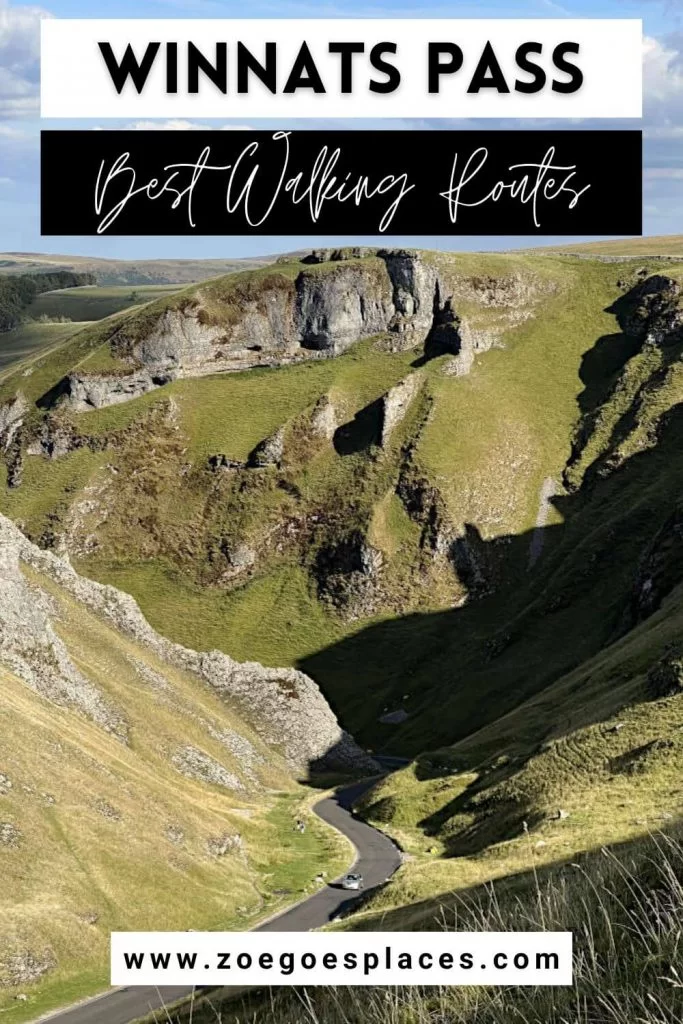
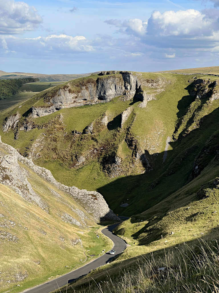
A Winnats Pass walk is a perfect way to get up close to the natural beauty of the Peak District. With its photogenic exposed rock, steep cliff edges and views for miles around, it’s hard to understand why it isn’t more popular.
Particularly, given that this natural beauty spot is surrounded by so many other tourist attractions. In fact, you can combine a visit to Winnats Pass Castleton with any of the nearby spots pretty easily as there’s no shortage of Peak District walks.
So, whether you’re looking for a circular route or to combine a Mam Tor and Winnats Pass hike, this guide has you covered. You’ll find out where you can park for free as well as get walk route maps, directions and downloads.
What & Where is Winnats Pass?
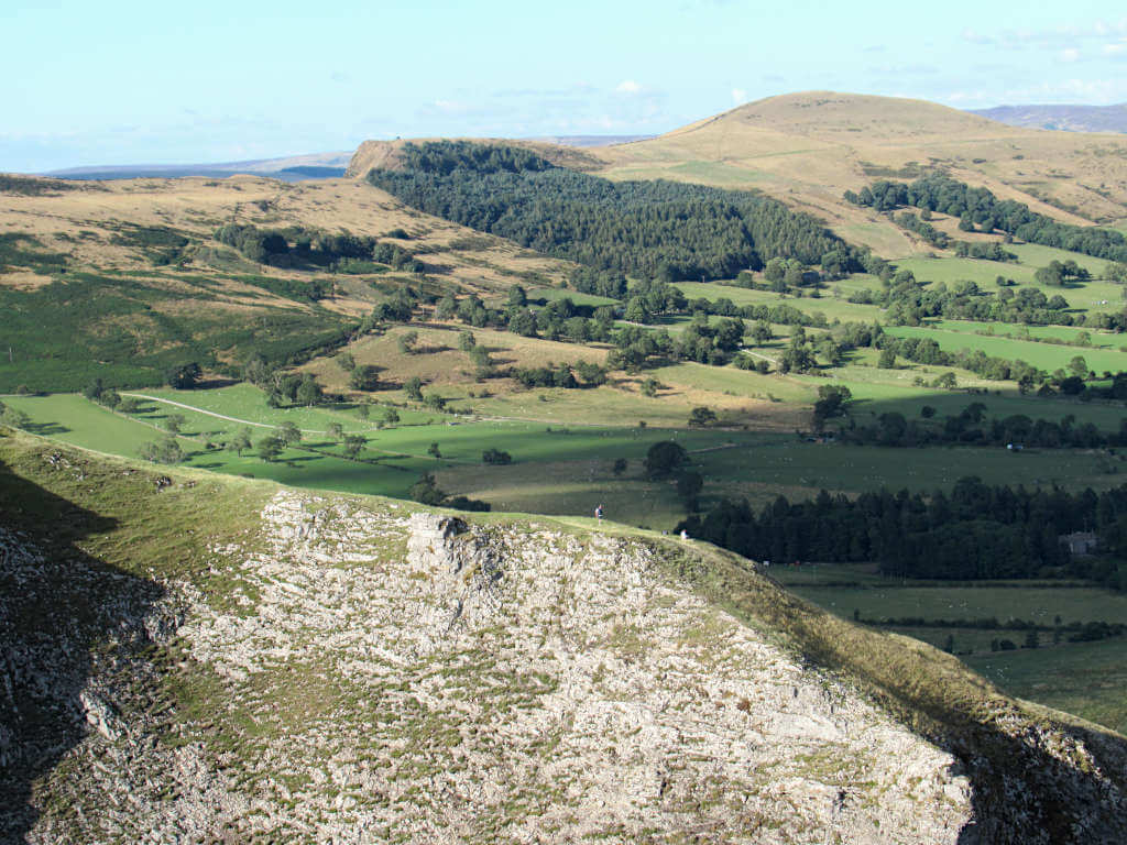
Winnats Pass is a narrow valley and gorge with steep sides and exposed rock in the Peak District National Park in England. Reaching a maximum incline of 28%, the road through the pass is popular with cyclists looking to test themselves. And also tests the traction and power of many cars!
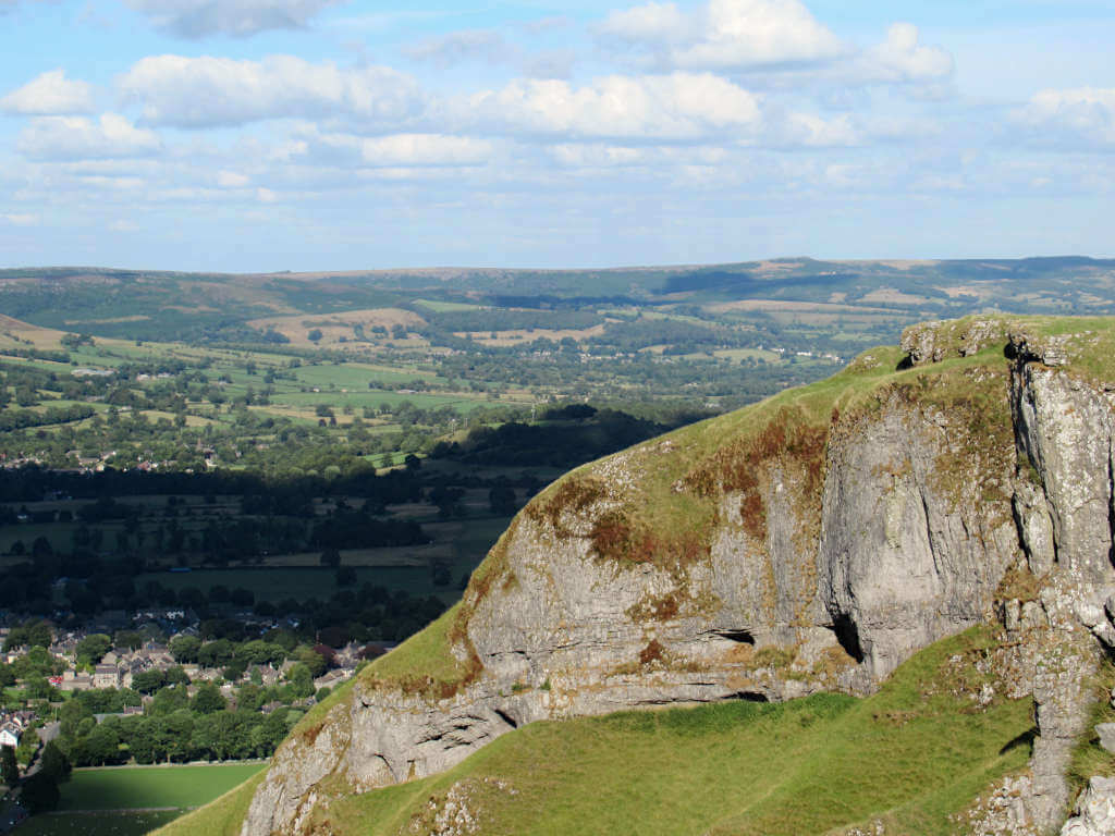
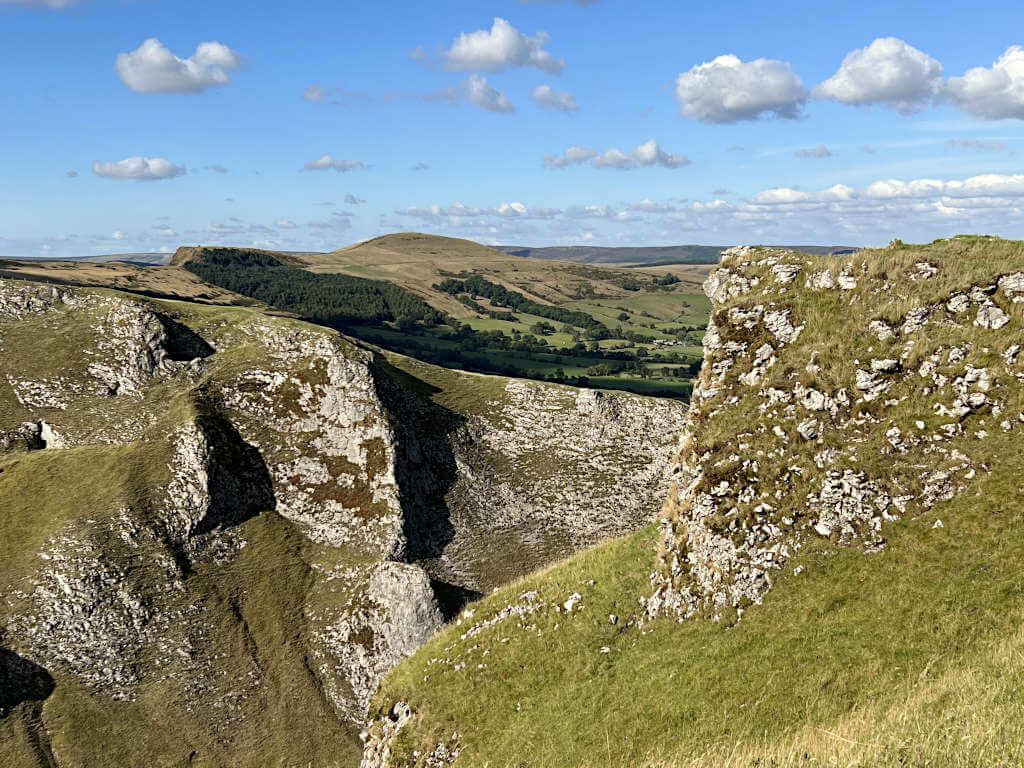
This popular spot is located west of the charming Derbyshire town of Castleton and under the shadow of nearby Mam Tor – one of the most visited peaks around. The gorge is also surrounded by plenty of caves as well as popular attractions such as Speedwell, Treak Cliff, Blue John and Peak Caverns.
Other nearby landmarks include the remains of Peveril Castle, Ladybower Reservoir, Win Hill, Bamford Edge and Kinder Scout. The latter of which is the highest point in the National Park.
Best Winnats PAss Walk Routes
Take your pick from these 3 Winnats Pass walking routes or use them as inspiration to create your own. It’s hard to go wrong when you’re visiting somewhere this beautiful!
Winnats PAss Walk: Short, Circular Option with free Parking
Distance: 2.5 miles/4.1 kilometres
Elevation gain: 193 metres
Difficulty: Easy
Walking time: 60 to 90 minutes
Start Point and Free Winnats Pass Parking
This walk starts on Old Mam Tor Road, where you’ll find free roadside parking along the entire length of the lane. This is the road next to Blue John Cavern, to the north of Winnats Pass Peak District.
Directions
- From Old Mam Tor Road, turn off along the small road heading downhill and round towards Blue John Cavern. Walk in front of the entrance and shop, entering the field through the gate.
- Walk across the field in the direction of the farmhouse, then take the path to the left of the building. At the road, exit the field through the small gate in the drystone wall.
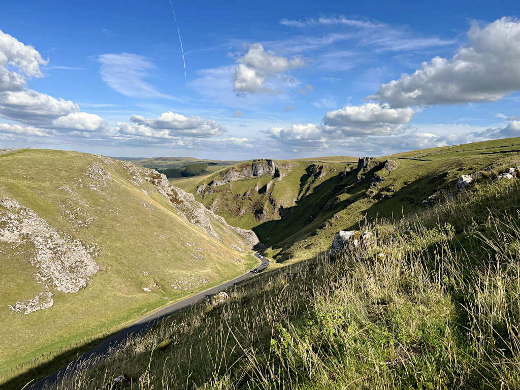
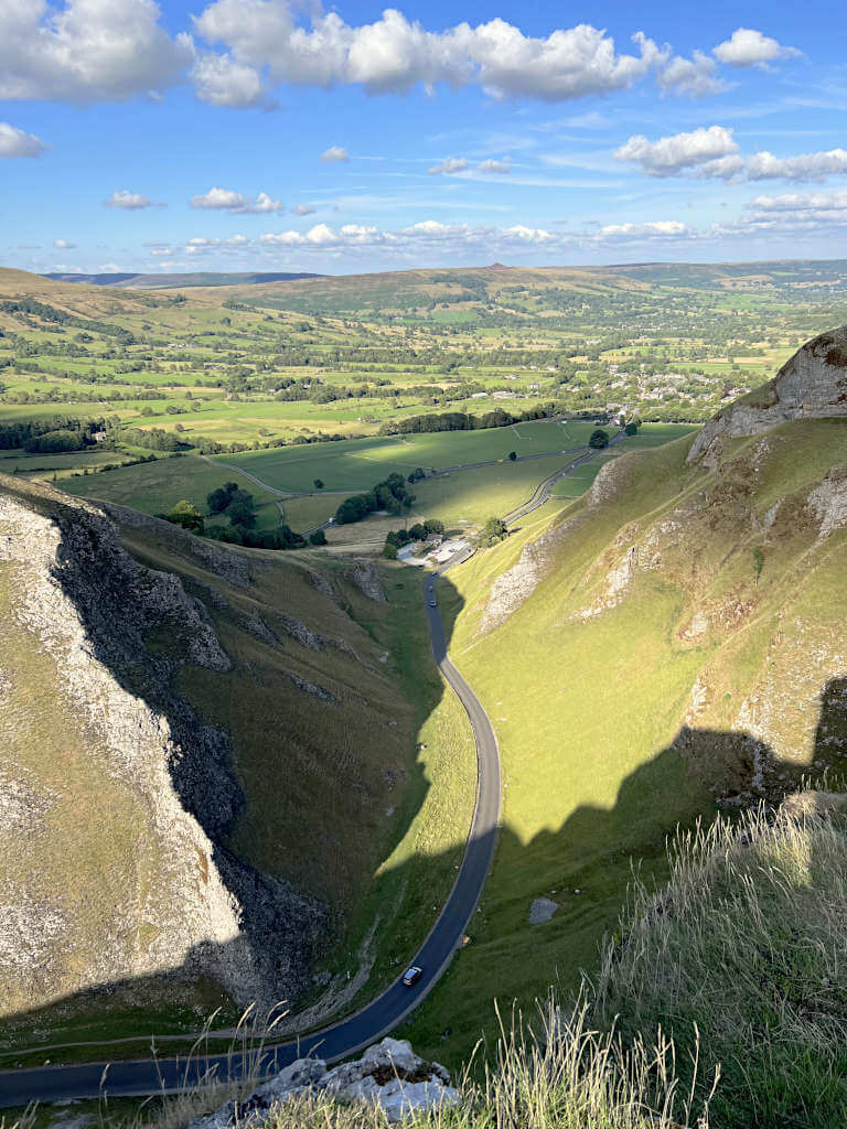
- Crossover and take the trodden path uphill almost exactly opposite you. Now, you can simply follow this along the top of Winnats Pass, taking in the incredible views as you go!
- The path runs parallel to a drystone wall all the way along the top before rounding a corner away from Winnats Pass. At this point, continue alongside the wall until you reach a steeper downhill section that is in a shallow valley.
- At the bottom, turn left and follow the path until you meet the road at Speedwell Cavern. Here, cross over the road and turn left again. Now, you can walk inside Winnats Pass, getting a totally different perspective.
- When you reach the cattle grid at the top, enter the field through the small wooden gate. Finally, make your way back across the field, past Blue John Cavern and back to Old Mam Tor Road.
For a shorter version of this walk, you can park in the pay and display car park at Speedwell Cavern.
Although the parking isn’t free, you can just walk up through Winnats Pass and back along the top. Without needing to walk across the field to Blue John Cavern and Old Mam Tor Road.
GRAB MY LIST OF MY FAVOURITE PEAK DISTRICT WALKS…
➡️ Is your New Year’s resolution to spend more time outdoors or exercise more?
➡️ Looking for more ideas for Peak District walks?
➡️ Want to explore more of this beautiful national park?
Save yourself the hours of research finding hidden gems and local favourites…
with this digital list of 52 beautiful Peak District walks full of my favourites from years of exploring.
Discover new places and spend more time in the great outdoors!
And – as a bonus – it includes 3 free trackers and challenge templates!
> > > BUY NOW FOR £2.99
> OR READ MORE

Winnats Pass Circular Route from Castleton
Distance: 2.9 miles/4.7 kilometres
Elevation gain: 212 metres
Difficulty: Easy to Moderate
Walking time: 1.5 to 2 hours
Start Point & Parking
This Winnats Pass circular route from Castleton starts in Peak Cavern Car Park on Buxton Road. Parking costs £7 for all day – unfortunately, there aren’t any payment options for just a few hours.
Alternative parking is available at Castleton Visitor Centre Car Park, which is also £7 for all day (24 hours). However, here also has the option of £2.50 for up to 2 hours, £4 for 4 hours and £6 for 10 hours.
Both car parks do get full on weekends and during school holidays or bank holidays, so you may just need to park where you can find a space. Pay and display spaces along Buxton Road are also available but also fill up quickly.
Directions
- Head out the back of the car park (the opposite side to the road) and turn right along the narrow lane. The road becomes a path as you head between stone walls before emerging into the fields.
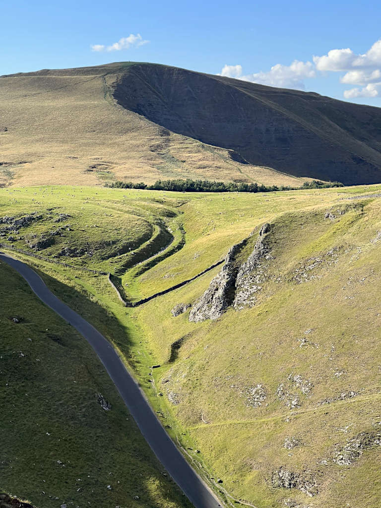
- As you walk along, you’ll get a great view of Mam Tor and the Great Ridge. After about 500 metres, turn left off of the path to head steeply uphill towards Winnats Pass Peak District. Turn right at the top and follow the path as it runs alongside the dry stone wall.
- As the path bends to the left, you’ll be at the top of Winnats Pass with panoramic views over the steep edges! Make your way slowly along the path, stopping as necessary for photos and to take it all in.
- At the road, cross over and enter the field through the small wooden gate. Follow the path round to the right and towards Blue John Cavern, as you pass the entrance, enter the field through the gate on the other side to where you came from.
- Follow the trodden path across the field and downhill, past Treak Cliff Cavern and down the steps. Just after the cavern, take the right-hand path off of the clear trail. Head across the grassy field until you reach Speedwell Cavern on the road.
- Turn left at the road then walk along Arthur’s Way and Buxton Road for 800 metres until you arrive back at the car park. Luckily, you’re right on the doorstep of Castleton for a well-deserved drink, snack, sit down or whatever your heart desires after this Winnats Pass walk!
Mam Tor & Winnats Pass Hike
Distance: 5.7 miles/9.1 kilometres
Elevation gain: 379 metres
Difficulty: Easy to Moderate
Walking time: 3 to 4 hours
Start Point & Parking
The Mam Tor and Winnats Pass circular route as described below starts and ends at Peak Cavern Car Park in Castleton. Alternative nearby parking is available on the roadside and at Castleton Visitor Centre, all of which are pay and display.
Another option is to park at Mam Nick Car Park about 600 metres from the summit of Mam Tor – and the westernmost point of this route. If you do this, you can follow the directions from that point and back round as the walk is completely circular.
Directions
- From Peak Cavern Car Park, head out the rear exit, turning right onto Goosehill. Follow the road as it becomes a path heading between the houses and emerging in the fields.
- After about 500 metres on the path, head left and steeply uphill – just after the drystone wall crosses the path. At the top, turn right and continue along the trodden path until you’re standing on the top of Winnats Pass Peak District. It’s pretty spectacular!
- Take in the views as you continue along Winnats Pass until you reach the road. Cross over and enter the field through the wooden gate. Next, follow the trodden path alongside the trees and the farmhouse. Pass through two drystone walls until you reach the road.
- Cross straight over and join the path by the Windy Knoll sign, continue diagonally across the field until you reach another road. Again, you’ll need to cross straight over and rejoin the path on the other side. Head straight – passing Mam Nick Car Park on your left – until you reach the steps to Mam Tor.
- Head uphill until you reach the trig point for Mam Tor – the views here are pretty incredible too! Then, when you’re ready, continue straight on along the Great Ridge all the way until you reach the steep, rocky climb to Back Tor.
- This peak provides sweeping views over Edale and the Dark Peak area including Kinder Scout behind. For the final leg back to Castleton, retrace your steps back down the rocky side of Back Tor. Then, turn left and head diagonally downhill away from the ridgeline. As you pass the small area of trees, take the right-hand path when it splits.
- Next, turn left when you reach a T-junction of paths and continue alongside the stream lined with trees. After 200 metres you’ll reach a road, follow this back to Castleton, turning right at the first two junctions. Finally, turn right when you reach the centre of Castleton and then keep straight to end up back at the car park.
How to get to Winnats Pass Peak District?
Where do I park to walk Winnats Pass?
Winnats Pass has lots of car parks around it. However, because it’s so close to other popular attractions such as Mam Tor, the caverns, Castleton and Peveril Castle, spaces do fill up quickly. This is especially true on weekends, bank holidays and sunny days during school holidays.
Winnats Pass Free Parking:
- Roadside parking along Old Mam Tor Road by Blue John Cavern with space for cars and campervans.
Pay and Display Winnats Pass Parking:
- Speedwell Cavern
- Peak Cavern Car Park
- Castleton Car Park (at Castleton Visitor Centre)
- Roadside parking on Buxton Road
- Roadside parking on Old Mam Tor Road (by the junction with Arthur’s Way/Winnats Pass Road)
Public Transport
The nearest train station is Hope, as Castleton does not have a train station. This station is serviced by the Sheffield to Manchester Line run by Northern Rail. Trains run roughly every hour throughout the day
Castleton is served by the 271 and 272 buses that run from the bus station in the centre of the town to Sheffield Interchange, via Bamford and Hathersage. Additionally, the 173 bus runs between Castleton and Bakewell, Monday to Saturday only. Further, the 256 is a Sunday- and bank holiday-only service running between Castleton and Sheffield via Chapel-en-le-Frith and Glossop (April to September only).
FAQs
Can you walk through Winnats Pass Castleton?
Absolutely! Although there is no pavement along the road, there is a path on the grass verge along the north side of Winnats Pass.
How long does it take to climb Winnats Pass?
This of course depends on where you walk from and what route you take. The closest parking is at Speedwell Cavern and from there you can probably reach the viewpoint overlooking Winnats Pass in 30 minutes.
However, this does require a bit of uphill climbing. For a mostly flat route, park near Blue John Cavern and start your walk at the higher end of the pass. This way, you’ll mostly be walking flat or on a slight incline. Then if you don’t want a steep downhill walk, you can simply turn around and walk back on yourself.
How do I get to Winnats Pass viewpoint?
The most photographed spot – or rather where most photos are taken – is located on the southern side above Winnats Pass, just above the bend in the road. It’s clear when you’re here as the path moves away from the dry stone wall at the top and towards the rocky overhang.
This place is great for photos and watching the world go by. But, of course, be careful. It’s pretty much a vertical drop over the edge!
Can you drive to the top of Winnats Pass Peak District?
No, you can drive through it. But, if you want to stand on the very top, you’ll need to walk. The paths are mostly trodden grass, although the Castleton to Winnats Pass walk route requires a steep uphill climb.
It’s also important to note, vehicles over 7.5 tonnes aren’t allowed to drive through Winnats Pass. Additionally, the steep incline is not good if you’re towing a caravan.
If you have any questions or want any more information drop a comment below and I’ll get back to you!
Prices and offerings mentioned are correct as of October 2022 but are subject to change in future.
More Peak District Walk Ideas…
STANAGE EDGE: 5 Best Walking Routes (1 to 8 Miles)
THOR’S CAVE: 4 Circular Walking Route Options From Wetton
SHINING TOR: Straight and Circular Route Guides
HARTINGTON: 5.3-Mile Walk in the Peak District Countryside
CHROME HILL: 3 Routes to the Spectacular Summit Views
ROACHES: Walking Route Map & Full Guide
LUD’S CHURCH: 3 Walks For An Other-Worldly Experience!
BAMFORD EDGE: 3 Easy-to-Follow Short & Circular Routes
PIN IT FOR LATER!