Whilst not the most dazzling or popular, this Shining Tor walk is still one of the best in the Peak District. It offers splendid views over the Peak Area, Cheshire Plain and the city of Manchester.
And, this guide gives you both two short and two long, circular walks.
Because sometimes you fancy a long weekend walk. And other times you just want some scenic fresh air and a countryside drive!
This guide is packed full of information for you to enjoy one of my top Peak District walks near Manchester. Including where to park, walk directions, GPS tracking maps and more!
I’m certain you’ll enjoy this walk, so keep reading and plan your next day out!
Where is Shining Tor Peak District?
Conveniently located mid-way between Macclesfield and Buxton, Shining Tor is near one of the most iconic Peak District pubs – The Cat and Fiddle (which is open again!).
Its closeness to Macclesfield means it’s also near Tegg’s Nose Country Park and Macclesfield Forest. Additionally, it’s located in the western part of the Peak District National Park and in the Goyt Valley, meaning it has incredibly scenic views!
Before we get into the Shining Tor walking route options, let’s answer some FAQs so you know what you’re getting yourself into…
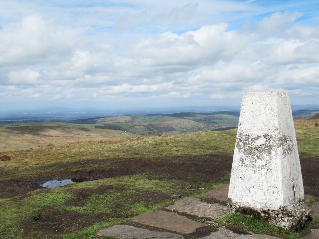
The Shining Tor elevation at its peak is 559 metres above sea level (roughly 1800 feet).
Manchester city centre, Manchester Airport, Jodrell Bank and the Cheshire Plain are the easiest to spot. On a clear day, you’re meant to be able to see Snowdonia in Wales. But, let’s just say, clear days don’t happen very often in this part of the world!
The peak and its walking routes are busiest on weekends, bank holidays and in school holidays. That said, while you’ll unlikely have the place to yourself, it’s only truly ‘busy’ a handful of days per year. As it isn’t one of the more popular Peak District walks.
There isn’t one single postcode for Shining Tor. Instead, you need to get to one of the nearby car parks. Unfortunately, the postcodes for these cover large rural areas, so aren’t a reliable way to end up in the right place.
Pym Chair is to the north and roadside parking near the Cat & Fiddle is to the south. Other nearby Shining Tor parking spots are on The Street, near the top of the reservoir, and Errwood Hall Car Park.
Shining Tor Walk from Pym Chair (Short, Straight Walk)
Distance: 4.0 miles/6.5 kilometres
Elevation gain: 167 metres (cumulative)
Difficulty: Easy
Walking time: 2 hours
Start and endpoint: Pym Chair Car Park
The quickest and easiest way to the top of a hill is always to drive as close to the top as possible.
Which, is exactly what this walk does! And, although it doesn’t stop you from having to walk uphill altogether, the incline is gentle and continual on the way to Shining Tor Peak District.
Parking
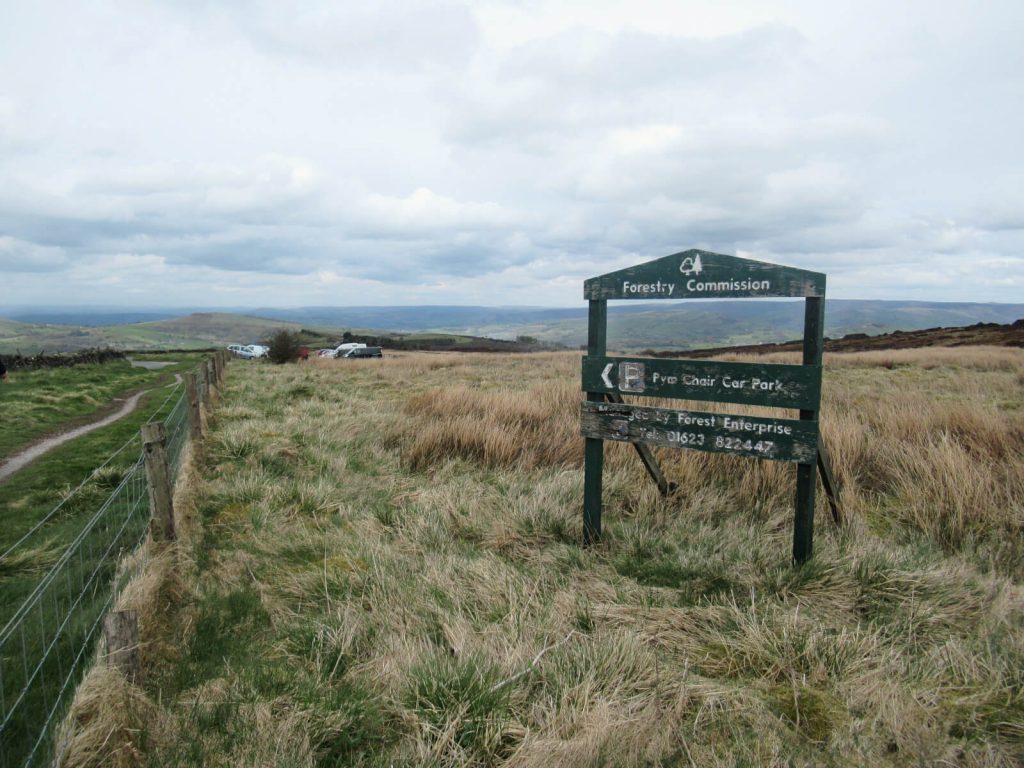
Free parking is available at Pym Chair Car Park off of Embridge Causeway on Side End Lane.
Pym Chair may also be one of the most scenic car parks in the whole Peak District. Located at an elevation of around 467 metres, views of Manchester and the Cheshire Plain can be clearly seen in most weather conditions.
The postcode for the car park covers a large, rural area, so avoid using a postcode as you’ll end up in the wrong place entirely! If needed, you can use its coordinates 53.287810, -2.009892 or Ordnance Survey grid reference SJ 99433 76757.
Start Point
For this Pym Chair to Shining Tor walking route, start at the corner of Embridge Causeway and Side End Lane – next to the sign for Pym Chair car park.
Pym Chair to Shining Tor Walk Directions
- Facing Embridge Causeway road, turn left and walk for about 50 metres. You’ll have to walk on the embankments as there are no pavements and it’s on a blind corner.
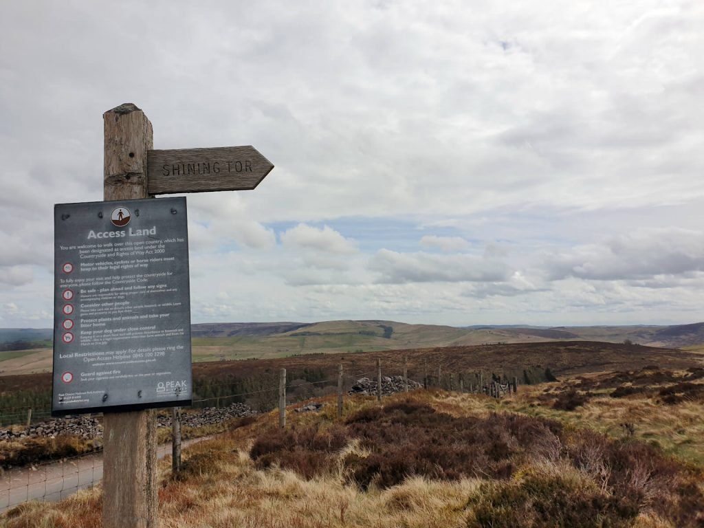
- Join the path on the right-hand side of the road – it’s behind a small wooden fence and has a signpost pointing towards the summit.
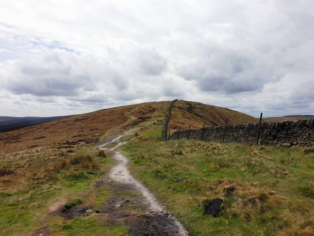
- The first small peak you reach is called Cats Tor. It’s not marked, so you won’t easily realise you’re there. But when you get to the part where there’s a small downhill section – that means you’ve passed it!
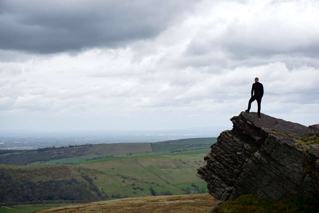
- 3.1 km from joining the path and 2.3 km after Cats Tor, you’ll reach the summit of Shining Tor Peak District. Luckily, this is very clearly marked! The trig point is behind a small stone wall and beyond that is a steeper drop with overhanging rocks that make for cool photos.
- The way back to the car park is simple and downhill. Turn left from the trig point gate and retrace your steps back along the path, past Cats Tor and all the way to the road! At a good pace, you’ll be back at the car park in less than an hour having completed your Shining Tor walk!
Cat and Fiddle Walk to Shining Tor (There-And-Back Route)
Distance: 2.8 miles/4.5 kilometres
Elevation gain: 44 metres
Difficulty: Easy
Walking time: 1 to 1.5 hours
Start and endpoint: Cat & Fiddle
Parking
Park on the gravel area opposite the Cat & Fiddle on the A537. The Cat & Fiddle car park is for customers only.
As with all the parking places for these routes, the postcode of the car park also covers a large rural area.
Unfortunately, this makes it impossible to navigate to the correct place using a postcode alone. Rather, use the Google Maps location, GPS coordinates (53.243854, -1.999486) or the OS grid reference (SK 00119 71872).
Start Point
From the parking area, the walk starts by following the A537 north from opposite the Cat & Fiddle.
Cat & Fiddle to Shining Tor Walking Route Directions
- Walk north along the A537 in the direction of Macclesfield – you can walk on the roadside banks to avoid being near passing traffic. As the road bends, take the footpath on the right-hand side.
- The path forks in two a short while after. Take the path on the right, signposted as ‘Shining Tor & Errwood‘. Careful not to confuse this with ‘Shining Tor & Errwood via Tearoom’.
- Follow the path slightly uphill for about 1 km. Take the path on the left and after 800 metres you’ll have reached the top and trig point – enjoy the view!
- To return to the Cat & Fiddle, simply retrace your steps back downhill, and turn right onto the more established path all the way until you reach the road. Then, the pub will be insight ahead.
Shining Tor Walk from Errwood Reservoir via Foxlow Edge (Circular Route)
Distance: 6.2 miles/10.0 kilometres
Elevation gain: 435 metres (cumulative)
Difficulty: Moderate
Walking time: 3 to 4 hours
Start and endpoint: The Street Car Park
Parking
Park at The Street Car Park, located on the junction of The Street and Goyt’s Lane at the north-western tip of Errwood Reservoir. Parking is free here and the car park is open 7 days a week.
However, the nearby (and popular) Errwood Hall Car Park is closed on Sundays. And so this can make The Street Car Park particularly busy on this day.
Alternatively, if The Street Car Park is full, park at Errwood Hall Car Park or at car parks around Errwood Reservoir.
Similarly to Pym Chair Car Park, the postcode for The Street Car Park covers a large rural area and is unreliable! If needed, use the coordinates 53.277480, -1.980871 or Ordnance Survey grid reference SK 01371 75613.
Start Point
Conveniently, this Shining Tor circular walk starts and ends in The Street Car Park.
Directions
First, Walk Across Foxlow Edge
- Head north-west out of the car park. Then, take the first left after 200 metres and then right after another 100 metres.
- Follow the path for 600 metres before turning to the right after a steady uphill climb. After approximately 300 metres, turn left just after the stone wall.
- Next, turn left onto the path that runs parallel to the trees. Stick to this path for about 1 km as it passes across Foxlow Edge.
- Here, you need to turn right – if you reach the point where the path forks in two, you’ve gone too far. Head steeply downhill and then join the path leading to the left.
Second, it’s a Slog to the Summit
- After another 300 metres heading downhill, you’ll get to a path T-junction, turn to the right. The path zig-zags for a bit here before gently curving to a pathway crossroads.
- Turn right and follow the path as it rises steeply uphill towards the Shining Tor ridgeline. After a 1 km uphill slog, turn left and continue the slow ascent to the summit – you made it!
- This is the perfect point for a break to take in the view, get those top-of-the-hill photos and recharge before the second half of the walk. Which, luckily is all downhill!
Finally, you’re on the Home Stretch via Errwood Hall
- After enjoying the trig point views, return to the track (over the wall) and start walking downhill to the right. After almost 1 km, take the path to the left, which descends even steeper towards Errwood Hall and Errwood Reservoir.
- Where the path forks, take the left-hand track and continue to zig-zag down from the top of Shining Tor Peak District.
- The path then circles the ruins of Errwood Hall – although, you can go off route slightly to explore these. As you follow the path around Errwood Hall, you’ll need to turn to the right and keep walking all the way down to the road at the reservoir.
- The final stage is to follow the road as it heads back to The Street Car Park – the path runs parallel to the road for the most part. But, if it is not busy then you can easily walk on the road.
Errwood Hall & Shining Tor Walk from The Cat & Fiddle (Circular Route)
Distance: 5.5 miles/8.8 kilometres
Elevation gain: 237 metres (cumulative)
Difficulty: Moderate
Walking time: 2.5 to 3.5 hours
Start and endpoint: Cat & Fiddle
Parking
There is a gravel area opposite the Cat & Fiddle that you can park on. The official car park is controlled by a third party and is for customers only unless you want a £60 fine.
A postcode won’t do you much good for navigating this rural area. Instead, use the GPS coordinates (53.243854, -1.999486) or the OS grid reference (SK 00119 71872) to get to the parking area.
Start Point
This Shining Tor circular walk route starts exactly at the parking area in front of the Cat & Fiddle.
Directions
from the Cat & Fiddle to Shining Tor Peak District
- Head north alongside the road in the direction of Macclesfield – use the roadside banks to avoid being near passing traffic. Then, as the road bends to the left, take the footpath on the right.
- Shortly after, the path forks in two – take the path on the right. This is signposted as ‘Shining Tor & Errwood‘. Be careful not to confuse this with the path heading straight towards ‘Shining Tor & Errwood via Tearoom’.
- Continue along the path slightly uphill for about 1 km. Then, take the path on the left and after 800 metres you’ll have reached the top of Shining Tor – enjoy the view!
Next, it’s on to Errwood Hall
- From the summit, turn left onto the path over the wall from the trig point and continue north along the stone path. After 1 km of downhill walking, take the path that goes to the right.
- There’s another 1 km of downhill walking before you near Errwood Hall. Follow the path around the mound before reaching the ruins.
And then Errwood Hall back to the Cat & Fiddle
- Once you’ve got your history fix and cool photos of Errwood Hall, it’s time to head uphill back towards the Cat & Fiddle.
- Navigate back around until you are at the path you came from Shining Tor on. Instead, of heading back towards the ridgeline, turn to the left and head south.
- The path zig-zags its way uphill and is easy to follow all the way until you meet the A537/Cat & Fiddle Road. From there, follow the road towards the Cat & Fiddle and car park that should be in sight.

Other Useful Information
- A pair of walking boots are more essential for the longer, circular walk – but will serve you well on either walk. For the shorter walks, a good pair of trainers will be fine unless it’s wet or icy.
- The Pym Chair Car Park to Shining Tor short walk route has a mostly large stone path. Whilst this keeps you off the mud and grass, it does make walking with a pushchair or using a wheelchair here practically impossible due to the gaps in the stones.
- Accessibility is not good on any of the routes, to be honest.
- Don’t forget to pack something warm for the summit! The trig point area is very exposed to those westerly winds and you’ll feel it in no time at all.
Do you have any questions or want any more information? If so, drop a comment below and I’ll get back to you!
Information correct as of April 2023 but is subject to change in future.
More Peak District Walks You Might Be Interested In…
CHROME HILL: 3 Routes to the Spectacular Summit Views
PADLEY GORGE: 4-Mile Route via Millstone Edge
THREE SHIRES HEAD: 4 Route Options from Gradbach & Wildboarclough
THE ROACHES: Walk Route & Full Guide for Panoramic Views
THOR’S CAVE: 4 Circular Route Options From Wetton
LUD’S CHURCH: 3 Walk Routes For An Other-Worldly Experience!
LATHKILL DALE: 6-Mile Waterfall Walk
HARTINGTON: 5.3-Mile Walk in the Peak District Countryside
MAM TOR: 4 Routes with Stunning Views
LADYBOWER RESERVOIR: 6-Mile Circular Route including Derwent Dam Viewpoint
PIN IT FOR LATER!
