This scenic and relaxing Ladybower Reservoir walk is one of just a handful in the Derbyshire Peak District that’s almost entirely flat. This route takes just 2 hours and gives you stunning views of the reservoir, Bamford Edge and Win Hill.
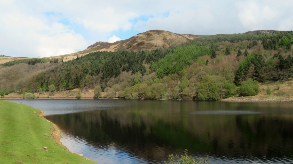
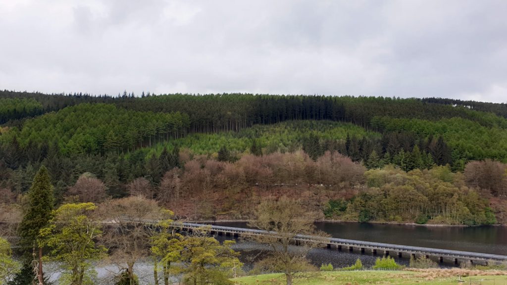
Ladybower Reservoir itself is a beautiful, Y-shaped body of water surrounded by striking hills, woodlands and near-endless walking trails. There’s also a visitor centre halfway along this route for refreshments and a toilet break.
And unlike many Ladybower walks online, this circular route has free parking. But, you’re gonna have to keep reading to find out where…
You’ll also find a walking route map, directions and all your FAQs answered in this complete guide to walking around Ladybower Reservoir.
Where is Ladybower Reservoir?
The reservoir is located in the heart of the Peak District National Park in the Upper Derwent Valley. It’s on the famous Snake Road running between Sheffield and Glossop.
To the north of Ladybower Reservoir are some of the most remote parts of the national park. And to the south are the villages of Bamford, Hope Valley, Hope and Hathersage.
Nearby landmarks include Bamford Edge, Stanage Edge, Alport Castles, Mam Tor, Winnats Pass, Derwent Edge and Derwent Reservoir and Dam. And, a trip to any of these can easily be coupled with a Ladybower walk.
Ladybower Reservoir Parking
Yes, there’s both free and paid-for parking either on the roadside or in car parks around the reservoir. Spaces do go quickly though, especially on weekends, so arrive early to avoid disappointment.
Where do you park to walk around Ladybower?
Free car parking is available in marked bays on the roadside of the A57 (Snake Road). The bays run for about 300 metres east of Ladybower Viaduct (Ashopton Viaduct), on the reservoir side of the road (westbound side).
For easy navigation to the parking spaces for this walk, use the following:
Postcode: S33 OAX
GPS coordinates: 53.374531, -1.707759
Ordnance Survey Grid Ref: SK 19559 86443
Alternative Ladybower Reservoir parking can be found along the western shore. Firstly, there’s a small free car park near the visitor centre – Derwent Overlook Car Park.
Additionally, the Upper Derwent Visitor Centre near the northern top of the reservoir has a car park. Parking costs £5 for the whole day. Also, Ladybower parking is available at Bridge End Car Park – £3 for all day (cash only).
Finally, near the Ladybower Dam and plughole, there’s paid-for parking at Heatherdene Car Park. Although, there are also a few free roadside spaces here.
Essential Route Details for this Ladybower Circular Walk
Distance: 6.0 miles/9.6 kilometres
Difficulty: Easy
Walking time: 2 hours
Start and endpoint: A57 (Snake Road) by Ashopton Viaduct, postcode: S33 0AX
Ladybower Reservoir Walk Map
GRAB MY LIST OF MY FAVOURITE PEAK DISTRICT WALKS…
➡️ Is your New Year’s resolution to spend more time outdoors or exercise more?
➡️ Looking for more ideas for Peak District walks?
➡️ Want to explore more of this beautiful national park?
Save yourself the hours of research finding hidden gems and local favourites…
with this digital list of 52 beautiful Peak District walks full of my favourites from years of exploring.
Discover new places and spend more time in the great outdoors!
And – as a bonus – it includes 3 free trackers and challenge templates!
> > > BUY NOW FOR £2.99
> OR READ MORE

Directions and Information
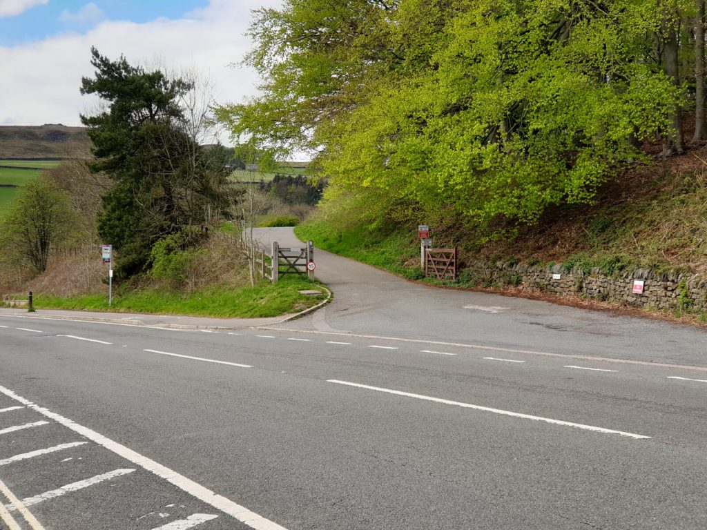
Walk Start Point
This Ladybower Reservoir circular walk starts (and ends) at the slip road that connects the A57 and the paths on the eastern side of the reservoir. The slip road is about 50 metres east of Ashopton Viaduct.
For absolute clarity, I’ve included a photo above so you can make sure you’re in the right place!
Ladybower Reservoir Directions
Not only is this walk easy to complete, but it’s also easy to follow. As, for the most part, you just follow the path around the water’s edge.
Nevertheless, below are directions to keep you on track. This will ensure you don’t miss any parts of this Ladybower Reservoir walk (particularly the Derwent Dam viewpoint).
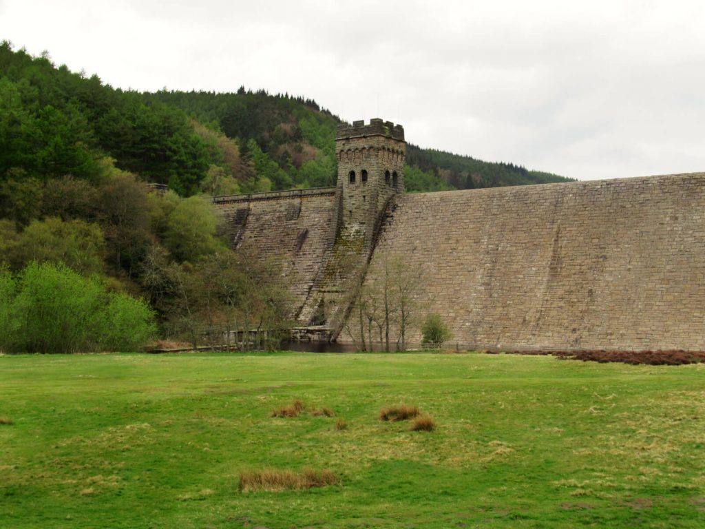
Not that you can miss Derwent Dam itself – it’s huge!
A57 to Derwent Dam Viewpoint (Ladybower Reservoir Circular Walk Part 1)
1. From the start point, follow the path along the eastern side of the reservoir heading north
After 1.7 km, you’ll come across a small beach area just off the path. This is a great viewpoint of the reservoir as you start to emerge from the woodland.
Another 1 km along the reservoir there’s a second water-level viewpoint. It’s a good place to stop for a drink or snack and enjoy the view.
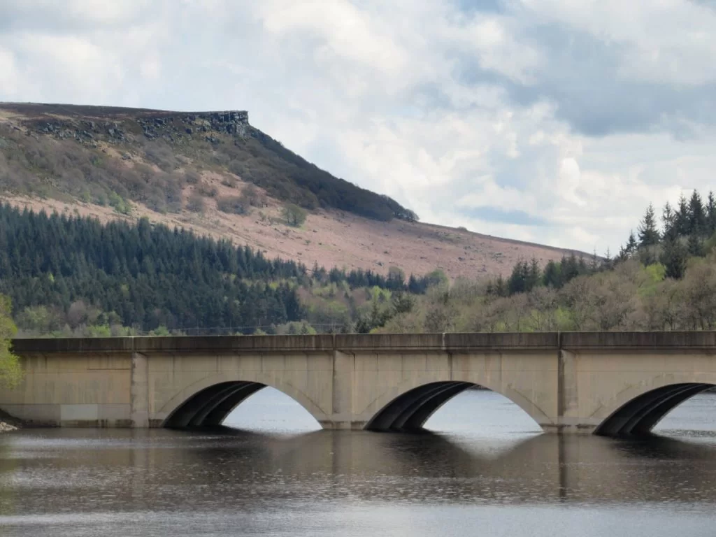
Derwent Dam is another 1.5 km further north and really cannot be missed. In drier weather and when water levels are low, you’ll likely only see a large brown wall. But, when the dam is flowing, this will be a powerful and imposing waterfall-like structure.
2. Cross the small bridge and take the path on the right-hand side towards Derwent Dam Reservoir wall through the trees.
After you’ve headed uphill and just beyond the reservoir wall, you’ll reach the Derwent Dam viewpoint. Take in views of Derwent Edge, Bamford Edge and Win Hill.
A few metres further along Derwent Reservoir is a memorial to Tip the Sheepdog. Who had stayed with her owner’s body for over 100 days back in 1954 until a rescue team found them.
Derwent Dam to A57 (Ladybower Reservoir Circular Walk Part 2)
3. Head south from Derwent Dam towards the Upper Derwent Visitor Centre and join the road.
From the viewpoint, it’s 500 metres south along the road until a small roundabout next to the visitor centre. At the Upper Derwent Visitor Centre (also known as Fairholmes Visitor Centre), you can use the toilets or buy some refreshments.
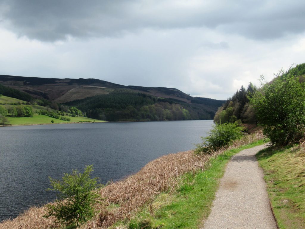
400 metres along the road, take the path on the left to get closer to the water’s edge. Continue along as it passes a few small bridges and weaves in and out of the woodland.
Continue for another 3.5 km until you see the arches of Ashopton Viaduct crossing Ladybower.
Just before the road, there’s a large grassy area that gives a stunning view of the viaduct with Bamford Edge in the background. The perfect place for a photo or two.
4. Turn left at the road and cross the Ladybower Viaduct.
Walk along the right-hand side for the best views over the rest of Ladybower, Win Hill and Bamford Edge.
The walk ends back at the slip road off the A57 where you started. You’ll just need to remember where you parked your car!
I’d recommend the nearby Yorkshire Bridge Inn for a well-deserved, post-walk drink or meal!
Click the link above to download the file for use in a GPS viewer. This way you’ll be able to track where you are on the route using your phone’s GPS – avoiding accidental detours and providing reassurance for less experienced countryside walkers! Once you’ve downloaded the GPX file above, install a GPX viewer app (Google PlayStore or iPhone App Store) and load the GPX file.
FAQs
Yes, the walks around Ladybower Reservoir are generally easy as they’re mostly flat at water level. However, as the reservoir is huge, the walks can be quite long. Especially if you want to do a circular walk.
To walk around the upper part of Ladybower (crossing Ashopton Viaduct) takes about 2 hours and is just under 6 miles. Walking around the whole Y-shaped Ladybower Reservoir is much more difficult. You’ll need to walk alongside roads without pavements, with a total distance of around 20 km (12.5 miles).
Enjoying a Ladybower circular walk (or a cycle) is one of the best activities in the area. With its stunning backdrop and calm waters, it’s not a walk to be missed.
Bike hire is available near the reservoir. Trails to the nearby Win Hill, Bamford Edge and Back Tor also complement walks around Ladybower Reservoir.
Yes, the car parks around Ladybower Reservoir are all open 24/7, 365 days a year. However, the car parks become full quickly, especially at peak times. At this time, the car park may be closed such that you cannot wait for another car to leave.
Planning to visit on a good weather weekend or during school holidays? Then it’s best to arrive early and have a backup car park if your first choice is full.

No, much like almost every other reservoir in the UK, swimming is prohibited.
Reasons for this include being in remote locations, a lack of lifeguards and very cold water. Also, large items can sadly be dumped in reservoirs causing hidden hazards due to the very low water visibility.
Yes, bikes are available to hire and the paths are perfect for fair-weather cyclists.
In this Ladybower walk, the only real uphill section is the climb to Derwent Dam viewpoint.
This can be challenging for lesser experienced cyclists. In this case, you can either skip the dam viewpoint or leave the bikes chained to a bench and continue on foot.
Yes, the main path that runs around the reservoir is mostly flat and a dirt track. The only substantial incline on this route is from the reservoir-level path to the Derwent Dam viewpoint, which you can skip.
And, while we’re on the topic of pram friendly, this Ladybower Reservoir walk is also good for children. As well as great views and greenery, there are also a couple of water-level viewpoints for skimming stones and getting close to the water.
Construction of the reservoir ended in 1943. But it wasn’t completely full of water until 1945.
In the 1990s, strengthening of the Ladybower Reservoir dam wall took place to prevent damage in case of major floods.
Growing water demands in the East Midlands required the construction of Ladybower Reservoir. This was in addition to Howden Reservoir (completed in 1912) and Derwent Reservoir (completed in 1916). Although, there was strong opposition to its construction at the time!
Howden and Derwent Reservoirs now flow into Ladybower. Which, in turn, supplies water to the treatment plant in Bamford. The three reservoirs supply water to the whole of Derbyshire as well as parts of neighbouring counties.
The villages of Ashopton and Derwent were flooded when the reservoir was filled. Before the flooding, demolition of most buildings in the villages took place.
However, the clock tower in Derwent was visible above the waterline until 1947, when it too was demolished for safety reasons.
Additionally, critically low water levels expose several buildings from the old village of Derwent. Which has been happening more and more in recent years.
Unfortunately, the interest in the exposed village sometimes leads to members of the public needing rescuing from the thick mud as well as the buildings being vandalised.
Do you have any questions or want any more information? If so, drop a comment below and I’ll get back to you!
Information correct as of April 2023 but is subject to change in future.
More Peak District Walks You Might Be Interested In…
SHINING TOR: Straight and Circular Walking Route Guides
CHROME HILL: 3 Routes to the Spectacular Summit Views
THE ROACHES: Walk Route & Full Guide for Panoramic Views
LUD’S CHURCH: 3 Walk Routes For An Other-Worldly Experience!
PADLEY GORGE: 4-Mile Route via Millstone Edge
THREE SHIRES HEAD: 4 Route Options from Gradbach & Wildboarclough
LATHKILL DALE: 6-Mile Waterfall Walk
HARTINGTON: 5.3-Mile Walk in the Peak District Countryside
MAM TOR: 4 Routes with Stunning Views
THOR’S CAVE: 4 Circular Route Options From Wetton
PIN IT FOR LATER!

I really enjoyed the Ladybower Reservoir walk. The views from the Derwent Dam Viewpoint were amazing.