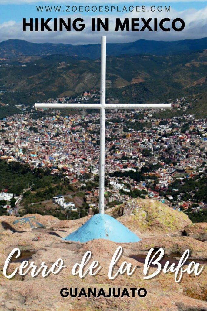
Looking for a fun, free, adventurous activity? Cerro de la Bufa Guanajuato is the thing for you – with incredible city views.
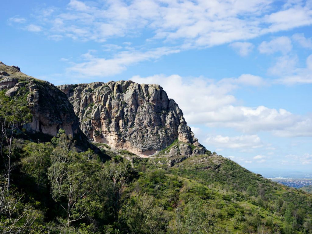
This cool rock formation is on the outskirts of Guanajuato City. And hiking to the top takes just a few hours.
The route is less than 5 miles there and back, through some of Guanajuato’s more scenic countryside. A perfect half-day activity for adventurous travellers, walking enthusiasts and those who love a viewpoint.
If this sounds like you, keep reading for the route, directions, downloadable GPX files and my top tips.
| Where is El Cerro de la Bufa? Getting to the Trailhead Route & Directions Top Tips & Review What to Bring and Wear | Review |
Walk Overview
Total distance: 4.4 miles/7.1 kilometres
Elevation gain: 227 metres
Difficulty: Moderate
Walking time: 2.5 to 3 hours
Start and endpoint: Car Park next to the ISSSTE Clinic Hospital of Guanajuato
Where is Cerro de la Bufa Guanajuato?
This epic rock formation is located south of the historic centre of Guanajuato City. Which is the capital of the state of Guanajuato.
The city is approximately a 5-hour drive from Mexico City. As well as 90 minutes from San Miguel de Allende and 4 hours from Guadalajara.
See the Google Maps pin for the very top of the rock here.
Getting to the walk start point
The Cerro de la Bufa Guanajuato trailhead is located on the outskirts of the city. The walk starts in a dirt car park next to the ISSSTE Clinic Hospital of Guanajuato.
You can see the exact location on Google Maps here.
To walk from the historic centre of Guanajuato to the trailhead takes around 30 minutes. And this includes a steep uphill walk in the city centre.
Alternatively, ride the Guanajuato Funicular uphill for 35 pesos and then walk along Panorámica Road all the way to the trailhead. It might not save you much time, but it’ll save you a good chunk of uphill walking – save that for later in the route!
Another option is to drive or take a taxi to the trailhead.
You can either flag down a taxi in the street or order one from the Uber app. I’d recommend having the location ready on your phone as the driver may not know where it is.
Cerro de la Bufa Guanajuato hiking route & directions
The path to the top of El Cerro de la Bufa is very easy to follow – for about the first 80% of the route. For the final section, you need to follow arrows painted onto the rocks and look ahead for where the path is heading.
No expert navigation skills are needed, but it’s a good idea to have a rough idea of what to expect to keep. Plus, I’m pretty sure these directions will make so much more sense once you’re on the route!
Save this page offline or as a PDF for reference during your walk.
Directions to La Bufa Guanajuato
1. Take the path leading out the back of the car park. When you reach the crossroads of dirt paths, turn to the left and head towards the power station, taking the path to the right of it.
2. Just after the power station, the road will split in two. Take the path on the left and follow it for 1.5 km.
3. The next landmark you’ll reach is the Cave of San Ignacio de Loyola, which is built into the rock face. It’s a nice shaded area to stop for a drink before the next part of the walk.
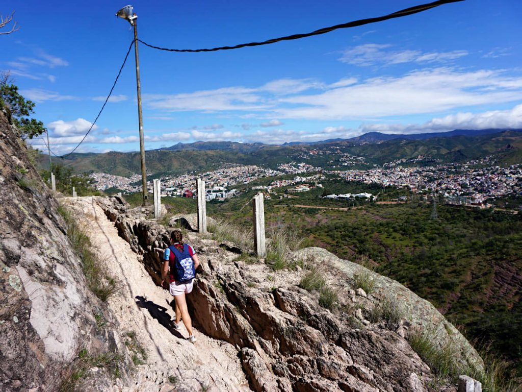
4. Continue following the path a while further – you’ll notice that there are lamp posts along the side of it now. You’ll come to a part of the path where you’ll probably not be sure where to go. One of the lamp posts will be on a lifted rocky part and there’s an arrow painted on a rock. Here, you need to start climbing up the rocks towards the top!
5. Keep following the arrows as you ascend – the route is relatively clear from the trodden parts and shape of the rocks.
6. You’ll reach a small plateau in the rocks, head left and continue upwards. Some steps have been made in the rock, climb these and you’ll reach the last section of the walk.
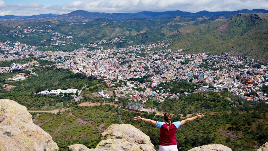
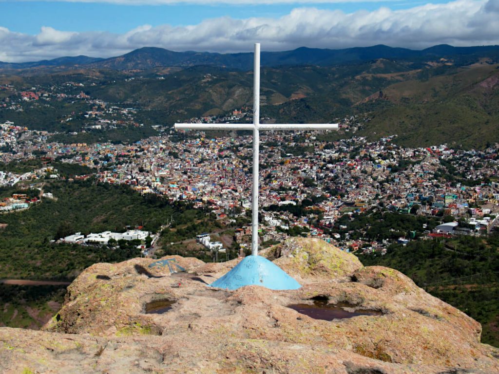
7. Continue across the rock – watch out for the gaps! Continue in the direction of the city until you reach the white cross on the cliff edge. Enjoy the view!
Once you’ve taken in the view, enjoyed a rest and snapped your photos, simply retrace your steps down the rocks, along the path, past the cave and all the way back to the car park where you started!
Route + Map
Download the GPX file below to follow your progress using GPS. You’ll need to download an app from the PlayStore or App Store that views GPX files.
But, this will then give you a Cerro de la Bufa Guanajuato map for your walk. This makes it easy to see if you’ve gone off-route.
Top Tips and Review
What you need to hike El Cerro de la Bufa Guanajuato
The route to the summit of La Bufa is pretty easy, it’s only the last uphill section that requires scrambling on rocks. As a result, no specialist gear is needed. Nevertheless, you want to be prepared for the activity and the climate.
Plenty of water.
Guanajuato is hot all year round, with daytime temperatures usually in the mid-twenties Celsius. Bring enough water to get you safely to the top, and more importantly, safely back to where you’re staying.
Weather-appropriate clothing.
For high temperatures or rain – or both. Trainers are suitable in dry weather.
Sun lotion.
There’s no shade at the top of the rock formation. And most of the route is in the sun too.
Sun cream up and reapply regularly – bring a hat if you have one too. Here’s some inspiration for the best sun hats suitable for travelling – from someone adamant they don’t suit hats.
Camera & Phone.
You’ll definitely be taking plenty of photos at the top as the views are incredible. Set off with a fully charged phone, offline maps (you can download from Google Maps) for navigating the city, and a good idea of where you’re going.
Snacks.
If you’re walking from Guanajuato centre then the total walking time will be at least 4 hours, and you’ll spend longer out taking in the views and having rest stops. Don’t underestimate the importance of fuelling your body before, during and after exercise.
Avoid bringing any snacks that’ll melt (this is hard for me as I LOVE chocolate).
Review
I loved everything about this walk – the views, the route, the weather, the lack of people around!
Walking from the centre of Guanajuato means there’s two long uphill sections. The first is getting out of the city and the second is the final climb to the top.
The rest of the route is surprisingly flat.
And, once you’re at the top, you’ll quickly forget about the long slog up – it will all be worth it! You can see for miles over Guanajuato and the surrounding area, no photo will do it justice.
The gorgeous year-round weather in Guanajuato makes it even better.
Blue skies and comfortable temperatures – not too hot and not too cold. You’ll want to complete the walk in daylight though to have the easiest time coming back down.
If you went for sunset then coming down the rocky part would be very difficult and probably quite dangerous. That part of the route isn’t lit. Check the sunset times in advance and plan to be done before then.
Finally, I hardly saw anyone during the entire walk.
In fact, I was at the very top for at least 30 minutes and there was no one else around. I had the whole summit to myself.
There’s lots of walking routes starting from the car park, including those popular with dog walkers. So don’t be disappointed if there’s already plenty of cars there.
For the best chance of peace, quiet and calm at the top, visit on a weekday and outside of public holidays. The 31 July is the festival of the cave and is very busy.
If you’re in Guanajuato, this HAS to be on your must-do list. A free, fun, all-day adventure!
If you have any questions or want any more information drop a comment below and I’ll get back to you!
The information is correct as of August 2023 but is subject to change in future.
More Mexico Travel Inspiration…
GUANAJUATO: Guanajuato Funicular: Everything You Need to Know [Travel Guide]
GUANAJUATO: Mirador de San Miguel de Allende: The City’s Best Viewpoint [Travel Guide]
PUEBLA: Ride the Teleférico Puebla for Panoramic City Views [Cable Car Guide]
GUERRERO: Pozas Azules de Atzala, Taxco (Visitor’s Guide)
CENTRAL OAXACA: San José del Pacifico, Oaxaca (Complete Travel Guide)
COASTAL OAXACA: Playa Bacocho, Puerto Escondido (Oaxaca Beach Guide)
And much more, check out all Mexico Travel Guides here!
PIN IT FOR LATER!